OPC Vacancy
Contiguous Parishes (our neighbours)
Burcombe – Durnford – Fugglestone St Peter with Bemerton – Great Wishford – Stapleford – Wilton – Woodford
Websites of Interest
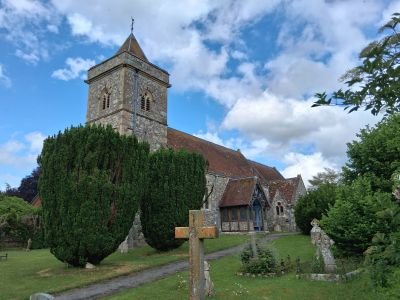
The Parish Church of St. Andrew
St. Andrew’s Church was built mainly of rubble with ashlar dressings and has flint and stone chequerwork. It consists of a chancel with a north chapel and south vestry, a nave with north aisle and a south porch and a west tower. Nearly all the external walling was rebuilt in 1861-2 to designs by T H Wyatt. The chancel and the aisle were built in the early 13th century, as was the chancel arch, which in 1861-2 was moved to become the tower arch. In 1553 a plate weighing 1.5 oz was confiscated and a chalice of 6.05 oz was left in the parish. The chalice was replaced by one hallmarked in 1576. Of the original four bells from 1553, two still hung in the church in 1993. A fifth bell was added in 1862 and a sixth in 1887.
St. Andrew’s Gallery St. Andrew’s Interior Gallery St. Andrew’s Churchyard Gallery
Church Clergy
Incumbents List 1550-1834 Suspension of Benefice 2018
Church Supported Charities and Funding
Parish Register Transcripts
Baptisms
Marriages
Note the marriages here are sorted in alphabetical order with bride and groom hence the two sets of marriages for the same date
Parish Registers held at WSHC
Baptisms 1695-1924
Marriages 1695-1994
Burials 1695-1902
Parish History
The parish of South Newton is immediately north of Wilton; a detached part North Ugford is immediately west of Wilton, in the main the parish is essentially the land of a 10th century estate bounded on the west by the river Wylie and on the east by a way along the ridge dividing the valleys of the Wylie and the Christchurch Avon. Four settlements grew up by the Wylie, South Newton, Little Wishford, Stofold and Chilhampton.
Burdens Ball to the south is a fifth settlement. The village stands beside the Wilton to Warminster road, The church, vicarage and Manor farm formed a group on the east side of the road. Manor farmhouse was rebuilt in 1799, the vicarage demolished in the mid 19th century.
North of the church there were farmsteads and other buildings on both sides of the road in the late 18th and early 19th centuries. Those that have survived on the east side are Newton cottage (thatched and dated 1679) and the Bell Inn (opened in 1759) which now occupies an 18th century house. The Plough was an Inn in the early 18th century. A fire in the village destroyed seven houses and three barns in the village in 1752.
South of the church, South Newton Mill has long stood on the River Wylie. By 1773 a line of buildings stood along the east side of the road, north of the mill. Newton House and a new vicarage were built just north of the church, both have now been converted into nursing homes. Pembroke cottage and a terrace of four houses are dated 1859. In 1993 the Earl of Pembroke and Montgomery owned most of the land.
Civil Registration
1837 – April 1936 Wilton Registration District
April 1936 – Present Salisbury Registration District
Buildings and Land
Agriculture
County Agriculture Report 1847
Fires
Enclosures
Notice of Petition for Inclosure 1808
Landowners
Property to Let
Public Houses
Bell Inn, Warminster Road
17th century origins.
Weather Phenomena
Crime and Legal Matters
Animal Cruelty
Killing a Neighbour’s Bees 1870
Bastardy
Miscellaneous Items
Crime Reports 1800-1849 Crime Reports 1850-1899
Prisons and Prisoners
Committed to the Devizes House of Correction & New Prison 1800-1849
Proceedings in Chancery Elizabeth I Era (1558-1603)
Transportation
William Whatley Sentenced to Transportation 1812 Transported for Theft of Fowls 1829 Robbery on the London Road 1839
Directories
Education
1783 no school in the parish
1818 three Dame schools had 75 pupils, 35 were children of paupers
1833 a small school, attended by 7 boys and 17 girls, opened
1838 National school, with a teachers house built. It had 58 pupils in 1846. The National school was described as clean and tidy and well conducted in 1858 when there were 30-40 pupils. That number rose to 75 by 1873 and in 1909 the average attendance was 58, falling to 22 in 1927; the school closed in 1935.
Emigration and Migration
Published in tables from the Poor Law Commissioners Annual Reports for 1835, 1836 and 1847-1848 the following may be of use for tracing missing ancestors. 14 paupers emigrated to South Australia under an assisted emigration programme between April 1839 – April 1840
Employment and Business
Agriculture
Gamekeepers Certificates 1807 Gamekeepers Certificates 1834 Agriculture Report 1847 Ploughing Match & Shepherding Prizes 1868
Apprentices
Apprentice records published here may not necessarily mean that the apprentice was from the parish but was apprenticed to a master within the parish.
William Absolom 1758 Daniel Beckingsale 1752 Mary Bracher 1720 Robert Carpenter 1724
Communications
British Postal Service Appointments 1737-1969
Community Services
Police
Wiltshire Constabulary 1858 Appeal for Police Constable for Wishford 1901
Miscellaneous Documents
Non Conformity and Other Places of Worship
People and Parish Notables
Associations, Clubs, Organisations and Societies
Agriculture
South Newton Agricultural Society Competition 1871 Agricultural Society Gathering 1872
Friendly Societies
Oddfellows Lodge Anniversary 1851
Census Returns Transcripts
1841 1851 1861 1871 1881 1891 1901 1911
Elections and Polls
Poll of Freeholders 1772 Poll Book 1818 Celebration for Mr. Benett’s Election 1819 Voters Lists 1832 Poll Book 1865 MP Nominations 2015 MP Nominations 2017
Family Notices
Inquests
Sport
Boxing Day Football Match v Great Wishford 1908
Poor Law, Charity and The Workhouse
Charities for the Poor
Some of the money given by Mr. Daniel for poor widows of the parish had been lost by 1786, thereafter Daniels charity comprised from £10 and distributed annually. J. H. Flooks yearly increased the amount by 10s. and in his will in 1844 he gave £50 to the charity. In 1901 each of 10 widows received 3s. 4d., in 1930 £2 0s. 5d was distributed, and in 1950 £1 10s. 4d. In the later 20th century the income was allowed to accumulate; £34 was distributed in 1961.
J. H. Flooks also gave in his will the income from £500 for bread for the poor of South Newton and Wilton. South Newton was to receive the bread in alternate years, but in the late 19th century received £7, half the income. Annually 210 gallons of bread were distributed in 1901, 102 gallons of bread shared by 227 recipients in 1930 and in 1960 £6. 7s. 0d. was spent on bread for 21 parishioners. Nothing further is known since 1960.
Wilton Union Guardians Appointed 1835 Guardians Dinner & Election of Guardians 1870
Overseers
Probate
Probate Index 1845-1851 (WSHC) Estate Notice of George Lush Deceased 1845
Inquisitions Post Mortem of Lands Held
Thomas Eyre 1629 Richard Grobham 1630 William, Earl of Pembroke 1630
Parishioners Wills
John Kyngman Proved 1522 John Blake 1553/1554 Alice Blake Proved 1566
War, Conflict and Military Matters
War Memorials & Military Gallery
| Autumn Manoeuvres 1872 | Reservists Leave for the Front 1899 | Diocese of Salisbury Memorial Book 1914-1918 | South Newton War Memorial |
| Roll of Honour Plaques |
WWI
Casualties
Acknowledgements
We would like to thank Jean Barnwell for her efforts as OPC for this parish
Burdens Ball
This was probably a single farmstead in the 16th century. A chapel, possibly from the 13th century, was demolished when only Burdens Ball farmhouse and two other houses stood there. The Wilton union workhouse was built north west of Kingsway and a chapel was built in 1864, served by the vicar of South Newton until 1940. The railway station opened in 1856 and closed in 1955. A gasworks was built in 1859 and closed in 1934. In 1990’s the former workhouse and sites of the station and gasworks were used for industry. Burdens Ball Manor was sometimes known as Fugglestone Manor.
Church Matters
Burthenstall (Burden’s Ball) Protestation Return 1641-1642
Chilhampton
In the Middle Ages and until the mid 19th Century, Chilhampton seems to have been a small settlement consisting of a line of farmsteads on the land of South Newton Manor. The road is likely to have been remade on a new course east of the village when it was turnpiked in 1761. 1800 there were about four farmsteads and several other houses and cottages. In 1993 the earl of Pembroke and Montgomery owned most of the land.
Church Matters
Chilhampton Protestation Return 1641-1642
Non Conformity
A house belonging to Stephen Wootton was licensed to hold meetings
Probate
John Blake 1610 William Blake Proved 1610
Little Wishford
History
A small settlement in the 14th century. In the 18th and early 19th centuries, Little Wishford consisted of no more than two groups of farm buildings, both of which stood to the south of the Warminster road; only one included a farmhouse in 1844. Little Wishford Farmhouse was rebuilt in the early 19th century. A large farm building called Crough’s barn was built north of Little Wishford farmhouse between 1957 and 1969. A church at Little Wishford was mentioned in 1428 but at no other time.
Church Matters
South Newton & Wishford Protestation Return 1641-1642
Stofold/Stoford/Stowford
History
The village comprised of a line of farmsteads on the land of South Newton Manor. The ford between Stofold and Great Wishford on the west bank of the Wyley had been replaced by a bridge by the early 18th century. The Earl of Pembroke and Montgomery owned most of the land in Stofold. There was a malthouse in the village in 1805 and brewers in 1848 and 1855.
Church Matters
Stowfold Protestation Return 1641-1642 Ringing for Five New Hats 1812
Buildings and Land
Fires
Fire at Mr. Gould’s Malthouse 1837
Public Houses
Swan Inn, A36
17th Century Coaching Inn overlooking the River Wylye and the Wylye Valley. Let 2020.
Education
1883 Stofold house was certified for use as a residential school for a maximum of 15 girls.
Non Conformity
1921 A small red brick chapel was built for United Methodists which closed in 1956
People and Parish Notables
Accidents
Inquests
Probate
John Blake 1545-1546 Thomas Blake Written 1549 John Blake Proved 1572 Maud Blake Proved 1616 John Blake Proved 1637
Ugford
Ugford was a village on the south side of the riverside road from Wilton to Mere. It had a church in the Middle Ages and its land belonged to Wilton Abbey. Known as Ugford St John in the 12 and 13th centuries; Ugford Abbess in the 16th century; Ugford St Giles in the 17th century; but more often known as North Ugford. South Ugford was on the south side of the river Nadder and apparently lost its identity in the late 18th century since when North Ugford has simply been known as Ugford. A cemetery for Wilton was opened in 1901 on land regarded as part of South Newton parish in 1844.
Church Matters
Ugford St Gyles Protestation Return 1641-1642
Non Conformity
1698 the house of George Blake registered for Presbyterian meetings
1777 the house of Joseph Horn registered as a meeting place
1798 the house of Susan Randall registered for unspecified worship
1807 a licence granted for Methodist meetings
1812 Methodist chapel built in 1812, demolished by 1900