OPC Vacancy
Contiguous Parishes (our neighbours)
Aldbourne – Little Bedwyn – Marlborough St. Mary – Ogbourne St. Andrew – Ogbourne St. George – Preshute – Ramsbury – Savernake
Websites of Interest
Mildenhall – Community website.
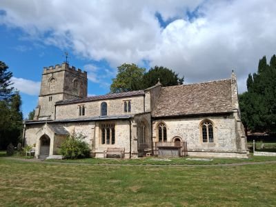
The Parish Church of St. John The Baptist
On the left bank of the Kennet below Marlborough is the interesting church of Mildenhall (pronounced “Mynal”). The building itself is almost entirely of the twelfth/thirteenth centuries and shows a number of details of the period, especially in the tower and nave arcades. But the grat delight of the church is its interior furnishing, brought in during the years 1815-16 and entirely Regency “Gothick” in style. The whole of this has survived, and comprises the box pews, a west gallery, a pulpit and lectern, a panelled and pewed chancel complete with reredos, and a font with its cover. A treasure to any county.
Built mostly of rubble with some brick and ashlar, has a chancel an aisled and clerestoried nave with a south porch, and a west tower. The chancel and the nave were rebuilt in the late 12th century, but the arcades, of which the south arcade is the earlier, probably follow the lines of earlier walls. The tower arch was probably added soon after that rebuilding and windows in the middle and lower stages of the tower, which have an 11th century character, may also be 12th century. In the 13th century the west doorway and a lancet window in the south aisle were inserted, but most of the windows are of the 15th and early 16th centuries. The top storey of the tower, the clerestory, and the nave roof date from the late middle ages. In the early 17th century the nave roof was embellished with pendants and ceiled, and about the same time the coved and panelled chancel ceiling was made. Much medieval glass was destroyed during the civil war. The late 18th century altar rails may be contemporary with the leather kneelers in 1796. The church was restored in 1814-16 when a large window was inserted in the south clerestory and the south porch was rebuilt. The nave and aisles were refurbished in a late Georgian Gothic style with box pews, a west gallery. and pulpit balanced by a reading desk, all of oak .Further restoration took place in 1871, 1949 and 1982.
St. John’s Gallery St. John’s Interior Gallery St. John’s Interior Wall & Floor Memorials Gallery St. John’s Churchyard Gallery
Churchyard Memorial Inscriptions Interior Wall & Floor Memorial Inscriptions
Royal Arms Baskerville Monument Church Refurbishment 1816 Re-opening of the Church 1952 Church History
Incumbents
Incumbents 1301-1574 Incumbents 1593-2019 Revd. Charles Francis 1821
Parish Register Transcripts
Baptisms
1560-1649 1650-1749 1750-1799 1800-1837
Marriages
Burials
Parish Registers held at WSHC
Baptisms 1560-1978
Marriages 1560-1996
Burials 1560-1901
Parish History
(Minal) is 1.5 miles from Marlborough, 9.5 miles from Hungerford, and 70 Miles from London. The parish lies north and south of the river Kennet. Tithings to the parish are Poulton and Stitchcombe. In 1377 there were 72 poll tax payers in Mildenhall, 8 in Poulton and 42 in Stitchcombe.
In the early 18th century and in the 20th century there were three small settlements in the tithing. Stichcombe and Poulton being two of the three.
Population and Other Information
Civil Registration
1837 – Present Marlborough Registration District
Buildings and Land
Mildenhall House, a former rectory house built in the village in 1860’s. The sites of Mere Farm and Grove Farm have been in use since 16th century or earlier. Warren farm was established in the 19th century and Mildenhall farm in the 20th. It is part of the Selkley hundred. There is evidence of pre -Roman activity in the parish, apart from several barrows and scattered artifacts, is a cemetery, possibly a war cemetery, of the early Iron Age. The site of a smaller Roman settlement has been found on the former Folly Farm.
A section of the Swindon, Marlborough and Andover Railway was built across the parish near the river Og and was opened in 1881. The line was closed to passengers in 1961 and for freight in 1964.
Sale of Savernake Estate 1929 Savernake Estate Sold 1929
Land Surveys
1936
Maps
Ordnance Surveyor’s Drawings 1818
Public Houses
The Horse Shoe
This was a beerhouse in the mid 19th century. Older Settlement sites east of the village include those of Durnsford Mill and Lucky Lane, a former farmhouse. Of the outlying farmsteads the earliest was at or near the modern Woodlands Farm. There was probably a farmstead at Woodlands in the 15th century, and in the 16th century tenants of the Mildenhall manor lived there. In the late 17th and early 18th century the lord of the Manor had a house there.
Many of the cottages date from the later 19th century and were probably built in the 1860’s when new building attracted new residents to the village. In the 20th century council houses were built east of the junction of the Ramsbury – Marlborough road and the Roman road to Cirencester, and private houses were built to the west end of the village. Infilling included council houses south of the village hall.
Crime and Legal Matters
Directories
Post Office 1855 Kellys 1867 Kellys 1915 Swindon & District 1928
Education
In 1808 some fourteen children attended a school kept by a poor woman in Mildenhall. The school had been shut by 1818, then the only form of education was Sunday schools and catechising.
In that year however Charles Francis, the rector, gave land and in 1821 he bequeathed £4,000 for a school. Half the money was invested and half used to build the school and a teachers house designed by Robert Abraham and completed in 1824. The building in perpendicular style, has a two storey octagonal central block and a lantern roof. From alternate sides radiate single storeyed wings, two of which were used as schoolrooms. The income from the investment £100 in 1858 was used to pay a master and a mistress and for the general expenses of the school. There were 28 pupils in 1833 and numbers rose to 60 and 70 in the late 19th century. By 1873 the central area of the of the school had been extended into additional classrooms, and in 1898 one of the original classrooms was enlarged. In 1906 the average attendance was 70. Numbers flutuate between 50 and 75 until 1938 when they stood at 40. The school closed in 1969.
Emigration and Migration
Employment and Business
Community Services
Police
Miscellaneous Documents
Non Conformity and Other Places of Worship
People and Parish Notables
Accidents
Census Returns
1841 1851 1861 1871 1881 1891 1901 1911
Elections, Polls and Voters Lists
Poll Book 1818 Voters Lists 1832 Voters Lists Revisions 1843 MP Nominations 2015
Family Notices
Parish Notables
Jack Ainslie – Farmer and Liberal Politician Phil Harding – Archaeologist Reg Prentice – Labour & Conservative Politician
Personal Research Items
Tuck Family Research Burial Extracts – This item was donated by Ken Tuck and contains entries that may or may not relate to the Tuck family however they have been published as such. Many refer to Quaker burials found across the county
Poor Law, Charity and the Workhouse
Probate
Inquisitions Post Mortem of Lands Held
William, Earl of Pembroke 1630
Parishioners Wills
War, Conflict and Military Matters
War Memorial & Military Gallery
WWI
Books of Remembrance & War Memorials
Diocese of Salisbury Memorial Book 1914-1918 Roll of Honour Plaque
Casualties
Poulton
Was one of the smallest and poorest tithings in Wiltshire. In the 18th century the hamlet consisted of two farmsteads, later called Poulton House and Poulton farm. Poulton farm then known as Little Poulton was rebuilt in the 19th century. There were 29 inhabitants of the hamlet in 1841, numbers may have increased in the late 19th and early 20th century when several cottages were built east of the Poulton – Aldbourne road.
Stitchcombe
This attractive tiny hamlet lies some 3 miles east of Marlborough on the River Kennet. The hamlet boasts a Manor house and a few houses. Until the 1920’s Werg Mill in the hamlet was still in operation. The mill was situated 500 metres east of Mildenhall Parish church Folly, later Forest Hill farm. Cottages were built near the northern end of Cock-a-troop Lane in the late 18th century and the 19th. Stitchcombe Mill, only part of which remains. On the steep slopes of the mill is Stitchcombe House, a farmhouse mainly in the 19th century. 1841 population was 127.
Buildings and Land
Savernake Cottage Hospital 1869
Acknowledgements
We would like to thank Jean Barnwell for her efforts as OPC for this parish