The OPC is Duncan McBurney
Manningford Bohune
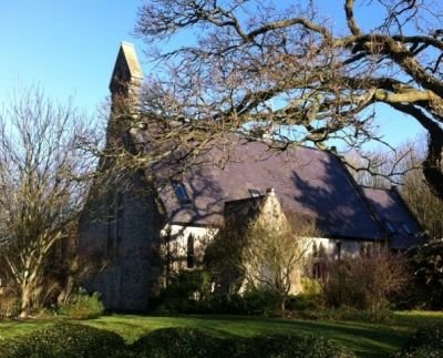
Manningford Bohune – All Saints
Parish Church of All Saints (The Old Church)
Parish Registers
Baptisms
Parish Registers held at WSHC
Baptisms 1859-1973
Marriages 1876-1937
Burials 1859-1978
Prior to 1859, baptisms, marriages and burials for conformist residents of the tithing of Manningford Bohune are most likely to be found in Wilsford, Manningford Bruce, North Newnton, or Woodborough.
Parish History
Manningford Bohune is a former detached tithing of the Parish of Wilsford. Between 1871 and 1934 it was a Civil Parish in its own right, before being amalgamated into the larger Civil Parish of Manningford.
In 1066 the territory of Manningford Bohune was owned by an individual named Godric, but by the time of the Doomsday Book in 1086 the new King had granted the lands to Amelric de Drewes. The land was valued at 3 and half hides and shared income from a Mill with Manningford Bruce, although the location of the Mill is not known.
It is possible that the Church at Manningford Bruce had originally also been shared, prior to the two parts being separated, as it sits on the western edge of Manningford Bruce and on the eastern edge of Manningford Bohune in what would have been the centre of a joint territory. As the Parish Church in Wilsford was 3 miles to the west, the inhabitants of Manningford Bohune are often to be found in the Parish Registers for Manningford Bruce. The Parish Churches of North Newnton, on the western boundary of Manningford Bohune, and Woodborough near to the settlement of Bottlesford, were also in regular use by conformist inhabitants of the tithing.
The old settlement of Manningford Bohune itself is largely to be found on a cul-de-sac now known as Wick Lane, which borders the Manningford Bohune Estate and that runs north from the Pewsey to Salisbury Road. Part of the settlement, known as Townsend, has spread onto the Pewsey to Salisbury Road. To the north of Wick Lane and the Manningford Bohune Estate lies what was Manningford Bohune Common. This covered a large expanse but was enclosed in the late 1700s. The area is still referred to as Manningford Common and comprises just a handful of houses and large open fields used for growing salad crops, forming part of Mullens Farm. The north eastern edge of the Common is also the location of the Old Church, being the Chapel of Ease finished in 1859.
On the northern edge of the tithing, which borders the Parish of Woodborough, lies the settlement of Bottlesford. This is a corruption of the name of Botwells Ford (early document may simply refer to Botwell). A small stream crosses the road through Bottlesford, the source of which is a spring at Alton Barnes and it joins the River Avon near Woodbridge in North Newnton. To the east of Bottlesford, and within the tithing, lies Nursery Farm (now largely part of Woodborough Garden Centre), which also includes an area of land known as Free Trade. It is likely that this name derives from an experiment in market gardening started in the late Victorian period.
Buildings and Land
Doomsday Book Entry
Amelric de Drewes holds of the King Maniford. Godric held it in the time of King Edward [the Confessor] and it was assessed at 3 hides and a half. Here is a ploughland and a half. There are 4 borderers. The third part of a mill pays 50 pence. Here are 12 acres of meadow, and the pasture is half a mile long, and 1 furlong and a half broad. It was valued at 30 shillings, now at 60 shillings. Source: Gentleman’s Magazine, and Historical Chronicle, Volume 34.
Crime and Legal Matters
Crime Reports 1800-1849 Trespass Alexander v Jesse 1824 Isaac Macklin Stealing Straw 1848
Directories
Emigration and Migration
Emigrants
Employment and Business
Bankruptcy of Jonathan Waight 1828
Non Conformity and Other Places of Worship
Baptists
A chapel for Particular Baptists was built at Bottlesford in 1842 and registered by John Keepence a year later. In 1851 it was known as the Ebenezer Baptist chapel with 30 people attending morning service, and 100 afternoon service, on Census Sunday that year. The chapel was closed in 1937 and is now a private dwelling.
In 1869 a red brick Baptist Chapel was constructed at Townsend in Manningford Bohune on the Pewsey to Salisbury Road. It is likely that this was constructed to replace the use of the house and premises of George Hawkins that was certified as a meeting place for Particular Baptists on 27th February 1840. At various times in the 19th Century the Chapel was described as a Particular, Strict and General Baptist Meeting House. The Meeting House is still in use as a Particular and Strict Baptist Meeting House. New Baptist Chapel 1870
Methodists
A house in the occupation of William Rudman was also certified as a meeting house for Methodists on 18th February 1819.
People and Parish Notables
Associations, Clubs, Organisations and Societies
Friendly Societies
Wiltshire Friendly Society
Census Returns Transcripts
Elections, Polls and Voters Lists
Poll Book 1818 Voters List 1832
Inquests
War, Conflict and Military Matters
Manningford Relief Landing Ground
In 1939 an airfield was opened on Manningford Bohune Common to operate as a Relief Landing Ground (RLG) for the nearby Central Flying School at RAF Upavon flying Avro Tutors, practicing takeoffs, landing and circuits. There were no buildings on the site, just a wind sock. The airfield was closed down in 1947 and returned to farmland (it is now part of Mullens Farm).